Hiking Mount Pantokrator Trails: Above the Clouds in Corfu
Rising dramatically from Corfu’s northeastern interior, Mount Pantokrator dominates the island’s skyline. At 906 meters, this limestone massif represents the highest point across Corfu’s entire extent. Hiking to its summit provides physical challenge, spectacular views, and intimate encounter with mountain ecosystems distinct from coastal environments. Multiple trails approach the peak, each offering unique character and rewards for those willing to trade beach lounging for mountain climbing.
The Mountain's Character and Significance
Pantokrator forms the backbone of Corfu’s mountainous northern region. The massif extends several kilometers, its ridgeline defining watersheds and creating microclimates dramatically different from surrounding lowlands. Limestone geology creates characteristic karst features including caves, sinkholes, and sharp ridges.
The name Pantokrator, meaning “Almighty” in Greek, reflects religious significance. The summit monastery, dedicated to Christ Pantokrator, dates to the 17th century though earlier structures existed. Pilgrimage traditions brought faithful climbing to the sacred peak for centuries before recreational hiking emerged.
Vegetation zones stratify by elevation. Lower slopes support olive groves and Mediterranean maquis. Mid-elevations feature mixed forests with oaks, pines, and diverse understory. Summit areas transition to alpine meadows and rocky outcrops where only hardy species survive exposure and thin soils.
Wildlife thrives in mountain habitats. Birds including raptors utilize updrafts along ridges. Mammals from foxes to wild boar inhabit forests. Reptiles including snakes sun on warm rocks. This biodiversity concentrates in relatively undisturbed mountain environments contrasting with developed coastal areas.
Weather patterns differ markedly from coastal conditions. Temperatures drop approximately 6°C per 1,000 meters elevation gain, making summit significantly cooler than sea level. Cloud formation concentrates around peaks with summit often shrouded while coasts remain clear. Winter brings occasional snow and ice unknown in lowlands.
Strategic military importance meant fortifications and observation posts occupied these heights historically. Venetian, British, and later Greek military installations recognized Pantokrator’s commanding position. Some ruins remain visible along trails, historical artifacts within natural landscape.
The Old Perithia Route
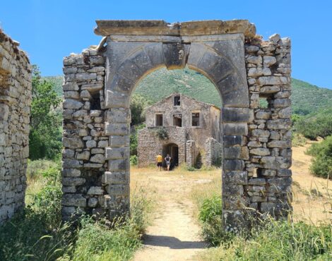
Starting from abandoned mountain village Old Perithia provides culturally rich approach. The village itself deserves exploration before hiking, its restored tavernas offering pre-hike sustenance and post-descent refreshment.
The trail begins behind the village, initially following old mule paths through terraced agriculture returning to forest. Stone walls and abandoned structures testify to once-intensive land use. This human history integrated with natural landscape creates layered interest beyond pure wilderness experience.
Early sections climb steadily through mixed forest. Shade provides relief during warm weather while fallen leaves create soft tread. The forest’s biological richness impresses botanically minded hikers, numerous species identifiable even by amateur naturalists. Spring wildflowers particularly reward attention.
After approximately 90 minutes, treeline transitions to more open terrain. Views begin opening across valleys toward Albanian mountains northward. The landscape becomes increasingly rocky, vegetation shifting to low shrubs and herbaceous plants adapted to exposure.
Summit approach follows ridge with dramatic dropoffs. Care required on exposed sections particularly during wind or wet conditions. The final climb brings monastery and telecommunications infrastructure into view, jarring modern intrusion into otherwise timeless landscape.
Total hiking time from Old Perithia ranges 2.5-3.5 hours ascending depending on pace and stops. Descent takes 2-2.5 hours. Round trip distance covers approximately 12 kilometers with 700 meters elevation gain, representing moderate to challenging difficulty for reasonably fit hikers.
Alternative Approaches and Routes
Spartilas village offers another popular trailhead at higher elevation than Old Perithia, reducing climb distance. The route follows forestry roads initially before connecting to footpaths. Less scenic than Old Perithia route but shorter and suitable for those with time limitations.
Strinilas approach from the west provides gentler gradient over longer distance. This route particularly beautiful during spring when alpine meadows bloom. The gradual climb suits less experienced hikers though extended duration requires proper pacing and time management.
Northeast coastal approaches from villages near Kassiopi present steepest, most challenging routes. These demanding trails reward with dramatic views and vertical accomplishment sense. Only experienced, fit hikers should attempt these routes requiring good navigation and stamina.
Traverse routes connecting villages across mountain flanks provide alternatives to summit ascents. These horizontal trails explore mid-elevation forests and agricultural zones while avoiding summit climb’s intensity. Excellent options for experiencing mountain environments without peak bagging emphasis.
Loop routes combining ascent and descent via different paths maximize variety. Planning loops requires detailed maps and good navigation skills but repays with diverse landscapes and reduced repetition compared to out-and-back routes.
Winter routes require different considerations. Snow and ice make some approaches dangerous while others become winter hiking and snowshoeing opportunities. Local inquiry about current conditions essential before attempting winter ascents.
Summit Experience and Views
Pantokrator’s summit presents mixed character. The monastery, usually open to visitors, offers spiritual dimension and architectural interest. Telecommunications towers, though aesthetically unfortunate, provide orientation landmarks. A small cafe operates during warmer months providing refreshments.
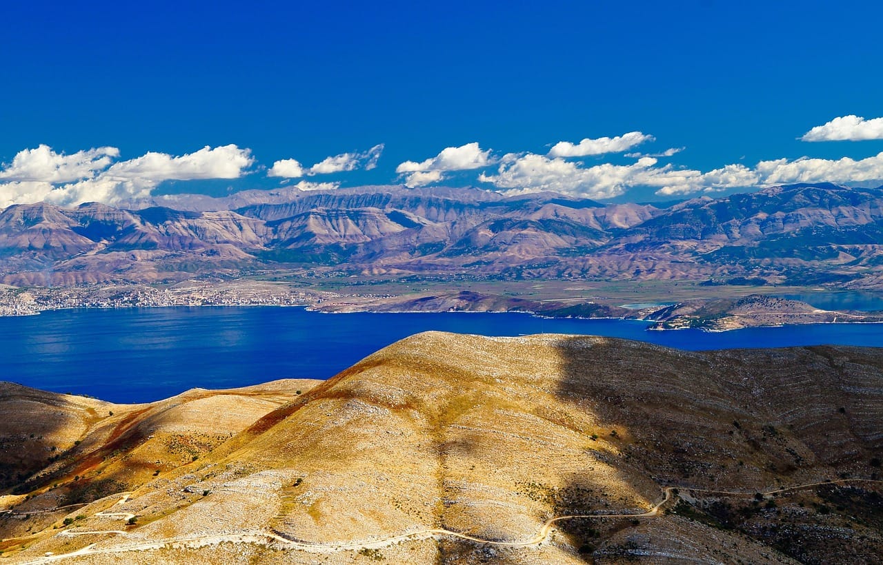
Views from the summit rank among Mediterranean’s finest. On clear days, visibility extends 50 kilometers or more in all directions. Albania’s coast appears startlingly close across narrow straits. Mainland Greek mountains rise eastward. The entire Ionian Sea spreads westward with Paxos visible on clearest days.
Corfu itself unfolds below in miniature. The island’s geography becomes comprehensible from this elevated perspective. Old Town, airport, lakes, major villages, and coastline features appear as map representations, abstract geography suddenly concrete and understandable.
Cloud phenomena add drama. Clouds frequently form below summit, creating sea-of-clouds effect with peaks protruding as islands. Watching clouds build and dissipate provides dynamic entertainment. Shadow patterns racing across landscape as clouds pass overhead mesmerize observers.
Light quality changes dramatically with time of day. Morning light illuminates eastern faces while casting western slopes in shadow. Afternoon reverses this pattern. Sunset from summit, though requiring descent in darkness, provides spectacular color displays. Dawn ascents, though demanding early starts, reward with magical light and frequent cloud inversions.
Temperature and wind exposure require warm layers even during summer. Summit can be 10-15°C cooler than coast with significant wind chill. Hikers regularly underestimate this, arriving unprepared. Carrying adequate clothing essential for comfort and safety.
Flora and Fauna Encounters
Botanical diversity increases with elevation as species zones stack vertically. Lower slopes feature Mediterranean maquis species including thyme, sage, and cistus. Mid-elevations introduce woodland species. Summit areas host alpine plants including rare endemic species found nowhere else.
Spring wildflower displays rival lowland shows with different species adapted to mountain conditions. Orchids particularly diverse across elevation ranges. Identifying and photographing wildflowers adds dimension to hiking beyond physical challenge and views.
Butterflies and other insects abound during warmer months. Endemic subspecies, variations found only on Corfu or limited ranges, reward specialist observation. Insect diversity indicates ecosystem health and provides food for birds and other wildlife.
Birds include species favoring mountain habitats. Raptors riding thermals, woodland species, and occasionally high-altitude migrants appear. Serious birders bring binoculars identifying species while casual observers simply enjoy diverse avian life.
Mammal encounters, though less common than birds, occasionally occur. Early morning or evening hikes increase wildlife sighting chances as many species avoid midday heat. Evidence including tracks, scat, and browse signs reveal animal presence even without direct sightings.
Reptiles including lizards and snakes bask on rocks and paths. Most species harmless though rare vipers require caution. Observing from respectful distance allows appreciation without disturbing or endangering either party.
Historical and Cultural Elements
Ancient paths crisscross mountains, routes used for millennia. Some trails follow Roman roads or medieval paths. Walking routes with such historical depth adds temporal dimension, imagining countless previous travelers.
Abandoned agricultural terraces and structures document mountain farming once supporting larger populations. Stone walls, cisterns, and building ruins appear throughout forests, human history integrated with natural landscape. Understanding this agricultural past enriches hiking beyond pure nature experience.
Charcoal burning platforms, circular flattened areas where charcoal production occurred, dot forests. This traditional industry supported communities while providing fuel. Recognizing these subtle features reveals invisible history.
Shepherd huts and seasonal settlements served pastoral economies. Though mostly abandoned, some still occasionally used. This continuation of traditional practices, however diminished, maintains cultural connections to mountain landscapes.
Religious shrines and small chapels mark trails and viewpoints. These spiritual markers reflect Orthodox traditions of blessing landscapes and seeking divine protection. Some receive annual pilgrimages maintaining centuries-old customs.
World War II remnants including fortifications and observation posts appear occasionally. The strategic importance that brought modern military installations to these heights extends back to ancient times. These artifacts layer 20th-century history onto much older human presence.
Safety Considerations and Preparation
Weather unpredictability requires preparation. Conditions change rapidly on mountains, clear mornings becoming stormy afternoons. Checking forecasts, carrying rain gear, and planning escape routes prevents weather-related emergencies.
Navigation skills essential on less-maintained trails. GPS devices or smartphone apps with downloaded offline maps provide backup to paper maps. Knowing basic navigation prevents getting lost even on well-marked routes where signage occasionally missing or vandalism occurs.
Water carries critical importance. No reliable sources exist on most routes requiring carrying all needed water. Dehydration significantly affects performance and judgment. Two liters minimum for summit attempts, more during hot weather.
Ankle protection and proper footwear prevent injuries. Rocky, uneven terrain punishes inadequate footwear. Hiking boots with ankle support reduce injury risk versus casual shoes or sandals.
Communication capability matters in emergencies. Mobile coverage exists but unreliably at elevation. Informing others of plans, expected return times, and route choices enables rescue if problems develop.
Physical fitness assessment honestly before attempting challenging routes prevents overextension. Summit attempts require sustained effort over several hours. Those unaccustomed to hiking should choose shorter, less demanding trails building fitness gradually.
Group hiking provides safety margins. Solo hiking, while offering solitude and personal challenge, increases risk should accidents occur. At minimum, informing others of plans essential for solo ventures.
Best Seasons and Timing
Spring, particularly April and May, offers ideal conditions. Moderate temperatures, blooming flora, and generally stable weather create perfect hiking environment. Crowds remain minimal outside peak summer season.
Early summer extends good conditions though temperatures rise. Morning starts avoid midday heat. June hiking remains pleasant with longer daylight hours providing flexibility.
Peak summer July and August bring heat making strenuous hiking challenging. Those attempting summer ascents should start very early morning, complete descent before afternoon heat peaks. Water requirements increase significantly.
Autumn, especially September and October, rivals spring for ideal conditions. Temperatures moderate after summer while weather generally remains stable. Fall colors add visual interest to forest sections.
Winter presents challenges including cold, wind, rain, and occasional snow. Experienced winter hikers can find excellent conditions but requires appropriate gear, skills, and caution. Many avoid winter mountain hiking entirely.
Dawn ascents, though demanding early rising, provide spectacular light, cooler temperatures, and often clearer air. Sunset timing requires preparation for dark descent or overnight summit stays.
Photography and Documentation
Panoramic summit views provide obvious photographic opportunities. Wide angle lenses capture sweeping vistas while telephoto compresses distant features. Varied focal lengths create diverse interpretations of same scene.
Macro photography along trails reveals botanical and insect subjects. Spring wildflowers and forest details reward close-up attention. This intimate photography contrasts with grand landscape shots, both documenting mountain experience.
Light quality changes throughout day affecting photographic results. Morning and evening provide warmest light while midday brings harsh contrast. Cloudy conditions create soft, even light for forest photography.
Human elements including hikers, monastery, and historical features add scale and interest. Including people in landscape shots provides perspective impossible to convey otherwise.
Documentation beyond photography including journaling, sketching, or recording audio captures ephemeral aspects like bird calls, wind, and personal thoughts. These multimedia approaches enrich memory beyond visual records alone.
Social media sharing extends experience while potentially encouraging others toward outdoor activities. However, geotagging sensitive locations requires consideration regarding overuse impacts. Balance sharing versus preservation benefits mountain environments.
Mount Pantokrator stands as Corfu’s vertical dimension, literal and metaphorical high point. Climbing its slopes and standing atop its summit provides perspectives unavailable from beaches and coastal attractions. The physical challenge, natural beauty, and cultural richness create experiences complementing rather than replacing coastal pleasures. Those investing effort reaching Corfu’s heights discover island dimensions invisible from below, understanding Corfu’s character through literal and figurative elevation.